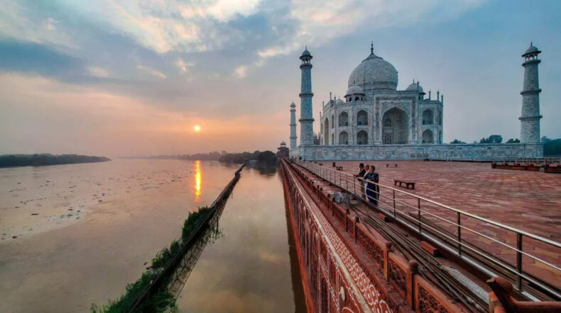
Yamuna becomes the reason for the worries that the 17th-century white marble monument will be damaged because a river that flows through the northern Indian state of Uttar Pradesh has risen to lap the Taj Mahal’s enclosure walls in the city of Agra.
After abnormally significant rain in northern India, especially Uttar Pradesh, which has gotten 108% of its typical rainfall since the four-month monsoon season started on June 1, the Yamuna River’s water level has risen during the past few days.
The Taj Mahal river segment climbed to 152 meters (499 feet) late on Tuesday, well beyond the 151.4-meter alert mark for potential danger, according to India’s Central Water Commission (CWC). The danger zone is at a height of 152.4 meters.
Images taken in the region on Tuesday showed the Taj Mahal’s red sandstone border wall surrounded by murky water with floating trash and the monument itself towering over the scene unaffected by the river.
There is currently “no serious concern” regarding the Taj Mahal, according to representatives of the Archaeological Survey of India (ASI), the organization in charge of managing it, and numerous other monuments around the nation.
Raj Kumar Patel, superintendent archaeologist of ASI, stated, “If it rains more or the water continues this high for several days, we would need to review the situation again.
However, he claimed that a number of other landmarks and gardens close to the banks of the Yamuna, near the Taj Mahal, “have been submerged” and ruined.
These include Mehtab Bagh, also from the 1600s, whose structure has been damaged and whose garden section – currently underwater – has been completely demolished, as well as the mausoleum of Itimad-ud-Daulah, also known as the “baby Taj” and dating back to the 1600s.
On Tuesday evening, despite the Taj Mahal’s rising water levels, tourists from all over the world kept pouring through its gates.
The Taj Mahal was stunning, but it is crazy to see the water rise so much, remarked Mathew Kreton, a 20-year-old student from Lucerne, Switzerland.
The locals were particularly worried because they thought the river would eventually enter their homes.
So that they won’t float away, we kept our possessions on top. Sundar Dubey, 49, who lives close to the temple, added that “In addition to that, we are continuing to be vigilant.
According to local media, the last time the river reached the monument’s walls—which the Mughal Emperor Shah Jahan erected in honour of his queen Mumtaz Mahal—was 45 years ago, in 1978.
Additionally, according to CWC data, the monument-area station measured the river’s greatest flood level that year at 154.76 metres.
When the 1978 floods occurred, Yamuna walked up to the Taj Mahal’s back wall. During this severe flooding incident, the water level grew to 508 feet, surpassing the high-flood record in Agra. 22 rooms in the monument’s basement were flooded during a time of heavy flooding 45 years ago, leaving behind silt.
The ASI claims that numerous additional sites, including Rambagh, Mehtab Bagh, Zohra Bagh, and Kala Gumbad, are also in danger due to the river’s rising level, but these are not now in danger.


