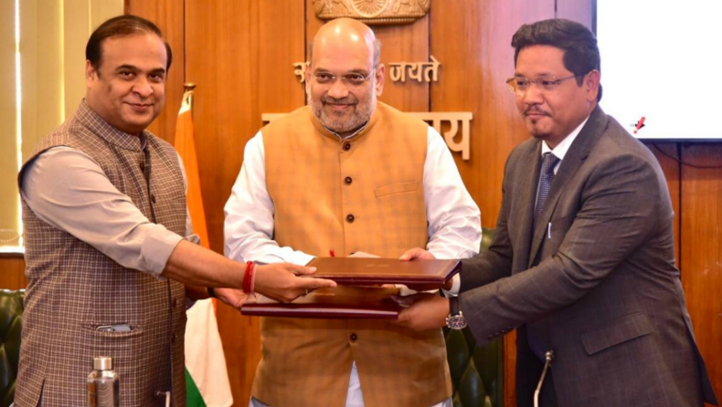
Assam Chief Ministers of Assam and Meghalaya signed a historic agreement for closure in six disputed sectors that were taken up for resolution in the first phase. The pact was inked in the presence of Home Minister Amit Shah in New Delhi with Himanta Biswa Sarma and his Meghalaya counterpart Conrad K. Sangma.
Home Minister Amit Shah hailed the resolution and said,
“This agreement exemplifies cooperative federalism and will provide a roadmap for resolution of other border disputes between states.”
About the Pact
The agreement was based on a draft resolution that was signed in January between the two States. This pack partially resolves a 50-year-old border dispute in six of the twelve sectors.
The twelve Assam-Meghalaya disputed areas: Upper Tarabari, Gazang reserve forest, Hahim, Langpih, Borduar, Boklapara, Nongwah, Matamur, Khanapara-Pilangkata, Deshdemoreah Block I and Block II, Khanduli and Retacherra.
The six disputed sectors taken up were: Tarabari, Gijang, Hahim, Baklapara, Khanapara-Pilingkata and Ratacherra. Tarabari, Gizang, Hahim, Boklapara, Khanapara-Pillangkata and Ratacherra under the Kamrup, Kamrup and Cachar are disputed districts of Assam. While the West Khasi Hills, Ri-Bhoi and East Jaintia Hills are disputed districts of Meghalaya.
Assam and Meghalaya have disputed sectors along their 885-km boundary. Out of it, 36.79 sq km of the disputed area was taken up for settlement in the first phase. With this agreement, Assam would get full control of 18.51 sq km and Meghalaya 18.28 sq km.
In June 2021, the two States had adopted a give-and-take policy for resolving the boundary dispute by constituting three regional committees. However, Assam Congress MLA Nandita Das, who represents the Boko Assembly constituency said,
“It was only give and no take on the part of Assam. If we go by the constitutional boundary and the Survey of India map, Meghalaya has been occupying all the disputed sectors.”
History of Assam-Meghalaya Dispute
Most of the Northeast states were largely carved out of Assam. Thus, most of the border disputes are in and around the state of Assam. Meghalaya was carved out of Assam in 1971 thus giving way to disputes over the demarcation of boundaries
The district of Langpih in West Garo Hills bordering the Kamrup district of Assam is a major point of contention between Assam and Meghalaya.
During the British colonial period, Langpih was part of the Kamrup district. But post-Independence, it became part of the Garo Hills and Meghalaya. However, Assam considers it to be part of the Mikir Hills.
Meghalaya raised apprehension on Blocks I and II of the Mikir Hills which is the Karbi Anglong region part of Assam. Meghalaya considers all of these as parts of erstwhile United Khasi and Jaintia Hills districts.
About the Settlement Attempts
In 1985, an official committee to resolve the issue was constituted under the former Chief Justice of India Y V Chandrachud with the then Assam chief minister Hiteshwar Saikia and Meghalaya chief minister Captain W A Sangma. However, a solution couldn’t be reached.
The present agreement was the outcome of border dispute settlement committees that was constituted by both Assam and Meghalaya.
Two regional committees were set up to resolve the border disputes in a phased manner with a consideration of five aspects: historical facts, ethnicity, administrative convenience, mood and sentiments of the people concerned and the contiguity of the land, in resolving the border dispute.
While reading out a statement issued by the Government Home Minister Amit Shah iterated,
“Looking at the journey from 2019 to 2022, we have seen many big achievements in establishing peace in the North East, NLFT agreement in August 2019, Bru-Reang agreement on January 16, 2020, Bodo agreement on January 27, 2020, Karbi-Anglong agreement on September 4, 2021, and today’s Assam-Meghalaya border agreement. Development of the Northeast is not possible unless disputes between states are resolved and armed groups surrender.”
Published by: Shivani bhalke
Edited by: Subbuthai Padma


