Hurricane Rick is a currently active tropical cyclone around the Pacific Mexico Coast that has churned up in the warm tropical waters of the eastern Pacific Ocean. The National Hurricane Centre alerted the coast posts on 18th October.
Current State
While heading to the Mexican southern Pacific coast, Hurricane Rick strengthened slightly on the night of October 24. It is most likely expected to make landfall on October 25.
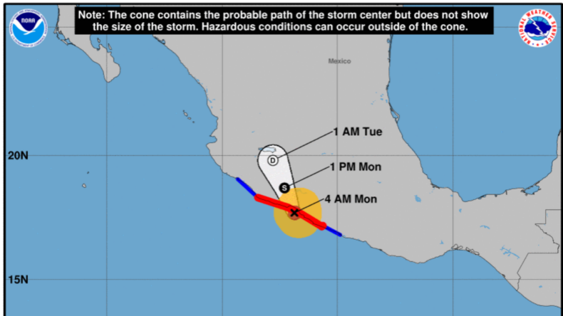
At 5 a.m. CDT Monday, Rick made landfall along the southern Mexico coast roughly 15 miles (25 km) east of Lazaro Cardenas. Rick was packing sustained winds of 105 mph (165 km/h) and was a Category 2 hurricane on the Saffir-Simpson Hurricane Wind Scale.
Conditions across this zone of the eastern Pacific were favourable enough to allow Rick to strengthen upon the final approach towards land.
The State of Guerrero, where Zihuatanejo and Acapulco are located, said rains and wind had already knocked over some trees and damaged a road.
However, through the morning hours on Monday, an increasing amount of interaction with mountainous terrain should weaken the hurricane as it moves inland.
The centre warned that Rick could produce flash floods and mudslides in the mountainous terrain on the coast.
Past updates
The hurricane was centred about 60 miles (100 kilometres) south of Zihuatanejo in late October 24 and was moving north at six mph (9 kph). The National Hurricane Center of the U.S said Rick had winds as high as 90 miles per hour (150 kph).
It was predicted to hit somewhere in the area from the seaport of Lazaro Cardenas to the resort of Zihuatanejo. Forecasters said the storm’s winds and rain could also affect the larger resort of Acapulco to the east.
Conditions began to go downhill late Saturday and early Sunday as the outer bands scraped the coast. During the same time frame, increasingly breezy conditions began to develop.
Preparations made
The seaport of Lazaro Cardenas said it had opened six emergency shelters for residents who might want to leave low-lying areas. Authorities in Zihuatanejo opened a shelter at the municipal auditorium.
“During its passage over land, it will cause intense torrential rains and possible mudslides and flooding, as well as rising levels in streams and rivers, in the States of Guerrero, Michoacan, Colima and Jalisco,” Mexico’s National Water Commission said in a statement.
After landfall on Monday, Rick will likely roll northward through central and northern Mexico. The rugged terrain will begin to shred the low-level circulation associated with Rick, resulting in a rapid decrease in wind intensity.
Rainfall will continue to be wrung out, potentially raising flooding concerns in Guadalajara, León and surrounding areas Monday night into Tuesday.
The remaining upper-level energy associated with Rick left after traversing the mountainous terrain of central and northern Mexico may then continue lifting northward by midweek.
While there is still time to monitor the evolution and track of the storm, residents in Texas and along the Gulf coast will want to keep an eye out for wet weather.
Guerrero’s education ministry said classes in the coastal area would be suspended on Monday, warning of heavy rain, strong wind gusts, and high waves in the Costa Grande region.
An eight-day lull in tropical activity in the eastern Pacific was snapped Friday morning as Tropical Depression 17-E formed roughly 500 miles south-southeast of Manzanillo, Mexico.
The swirling mass of showers and thunderstorms strengthened further by Friday afternoon, becoming the 17th named storm of the East Pacific season, Tropical Storm Rick.
It is less likely to have any colossal damage, but precautions are taken.


