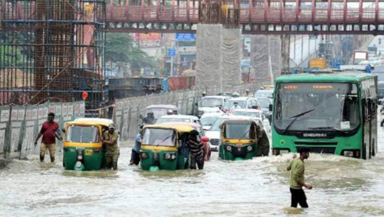
Between September 1 and September 5, 2022, Bangalore was devastated by rain, which inundated several regions of the city (Rainbow Drive layout, Sunny Brooks layout, Bellandur, Eco Board and some areas on Sarjapur road).
The anthropocentric causes
In addition to the negative effects of rain being exacerbated by climate change, there are numerous man-made factors that act as a catalyst. These factors range from major ones like layout planning and the development of public infrastructure to minor ones like garbage management.
Bangalore expansion and drainage area encroachment
The residents suffer disproportionately from “unscientific layout planning against the order of nature.”
Bangalore is believed to have dawned during the rule of Palegar Kempegowda during the 15th – 16th century. Unlike the seismically sensitive zones of the Himalayan states, the city’s topography was all-weather resilient, with interconnected lakes and moderately thick forests.
The then-administrators (native kings and the British) built reservoirs, public tanks, fortified lakes, and a sufficient number of drainage channels and large canals to transport wastewater in order to maximize the residents’ quality of life.
The use of eco-friendly organic cleaning products and an excellent wastewater management system prevented contamination of the drinking water.
People relied on open defecation or a proper drainage channel in case of a clustered area to collect drainage, and the human excreta was used as natural manure, as mentioned in Vedic scriptures and Sindhu-Saraswati civilization.
However, as a result of urbanization, population growth, and chemical technology, drains were hastily constructed, contaminating sources of drinking water and rendering inorganic sewage water unusable for any purpose.

What shortcomings exist in policy planning
After the colonial era, Bangalore dramatically grew by absorbing nearby villages into the Bhruhat Bengaluru Mahanagara Palike (BBMP), which resulted in a decline in the amount of greenery, lakes, and their catchment areas.

Between 2001 and 2020, Varthur Lake‘s catchment area decreased by 79 to 32 percent, and its green cover decreased by 34 to 12 percent.
Simultaneously the catchment area of Bellandur lake has shrunk from 58% to 16%.
| Era |
Year |
Increase in Spatial area (sq. km) |
| Hyder Ali |
1700 – 1790 |
2 |
| British & Mysore Sansthan |
1800 – 1947 1951 |
69 69 |
| BDA |
1963 – 1964 1969 1979 1995 |
69 112 134 161 |
| BBMP |
2006 2011 |
696 741 |
Credit: IISc

Bangalore’s green cover decreased from 1973 to 2020 because of urbanization.
The city once had between 280 and 300 lakes, but only 17 to 20 remain today. Urban slums are transformed into playgrounds, stadiums, commercial complexes, etc. as a result of unauthorised private intrusion.
The remaining lakes are Ulsoor, Bellandur, Sankey, Madiwala, Lalbagh, Hebbal, Agara, Varthur, Vengaihanakere, Jaraganahalli, Vibhutipira, Nagavara, Kengeri, Kempambidhi, Hesaraghatta, Puttenahalli, and Yediyur.
The National Environmental Engineering Research Institute (NEERI) has published a report stating that at least 16 lakes are completely encroached and are not likely to be restored. These are:-
Agrahara, Belakahalli, Bovimaranahalli, Byatagunte Palya, Chikkalsandra, Doresanipalya Geddalahalli, Gundopanth, Ittmadu, Karisandra, Konena Agrahara, Lingarajapura Sanigoruvahalli, Nandi Shettappa, Shivanahalli, and Vijanapur are among them.
The Indian Institute of Science report also reveals that only 30% of Bengaluru’s 360 officially recognized slums have underground sewage systems, with the majority discharging their wastewater into lakes via stormwater drains. Even sewage from apartment buildings is dumped into lakes.
Another factor thought to be responsible for lakes disappearing is the indiscriminate drilling of borewells. More than 1,25,000 borewells exist in Bengaluru, and the city’s water table has fallen to a level of 400 feet. There are currently 211 vulnerable sites in the city. The apartments and flats are built on hilly and elevated areas to protect from floods, but they have poor rainwater management, which hinders the natural system of water percolation.


Solutions
The only solution after a mistake is to rectify the flaws rather blaming.
- Some residents in the Mahadevapura zone’s Challaghatta, Chinnappanahalli, Basavananagar, and SR Layout wards who received eviction notices are uncooperative with the authorities,
As a result, the landlords are responsible for paying them back, and the government agencies that approved the construction must pay a price.
- In order to allow water to percolate, apartments and flats located in highly elevated areas must immediately implement a rainwater management system.
- According to reports, corruption is primarily to blame for the ongoing infrastructure constructions (metro, outer ring road), which calls for an investigation.
- Implement a transparent and ethical contract bidding process to stop funds being misappropriated because of favoritism.
- To reduce city pollution, organize eco-festivals and green gatherings to support citizen-centric initiatives, instead of using imprisonment to punish minor offences, emulate western nations’ use of community service.
- Check for unauthorized encroachment by pavement canteens and urban slums that block drains with their garbage dumping and evade taxes.
What are the other ways to mitigate the eventualities in your locality?
Comment your views below, thankyou
Read More –
- Heavy rains trigger flash floods and landslides in Himachal Pradesh
- Bengaluru residents allege bias in demolition drive, govt denies | Latest News India – Hindustan Times


