Tuvalu has stated that it is planning for the “deadliest scenario.”
Tuvalu’s foreign minister said on Tuesday that the Pacific Island country is looking into legal options to preserve the control of its marine zones and recognition as a state even if it is fully submerged due to the climate disaster.
In an interview with Reuters, the minister, Simon Kofe, said, “We’re truly contemplating a worst-case situation where we’re forced to evacuate, or our lands are drowned.”
We’re looking into legal options that will allow us to keep our control of our marine zones as well as our international recognition as a state.” So, going ahead, those are the things we’re doing,” he explained.
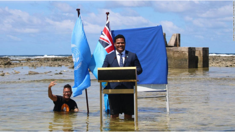
Images of Kofe standing knee-deep in the sea while giving a speech for the UN Cop26 climate summit have gone viral on social media recently, praising the tiny island nation advocating for bold action to mitigate the effects of climate change.
In Jenrok settlement, Majuro atoll, a girl wanders through the graveyard.
About Tuvalu Island:
Tuvalu is in the Polynesian subregion of Oceania. It’s a Pacific Island in the middle of the ocean, midway between Hawaii and Australia.
They are north of Fiji, northeast of Vanuatu, southeast of Nauru, south of Kiribati, west of Tokelau, northwest of Samoa and Wallis and Futuna, and northwest of Samoa and Wallis and Futuna. They are located east-northeast of the Santa Cruz Islands in the Solomon Islands.
Tuvalu is made of three reef islands and six atolls. They are respectively positioned at 5° and 10° south latitude and 176° and 180° longitude.
They are located to the west of the International Date Line. Tuvalu’s population is 10,507 people (2017 census). Tuvalu’s islands have a total land area of 26 square kilometres.
According to well-established hypotheses concerning a three-thousand-year-old migration of Polynesians into the Pacific, the initial residents of Tuvalu were Polynesians.
Polynesians routinely travelled between islands by canoe long before European contact with the Pacific islands.
Polynesian navigation abilities allowed them to travel in double-hulled sailing canoes or outrigger canoes on well-planned excursions.
According to scholars, Polynesians have moved out from Samoa and Tonga into the Tuvaluan atolls, which subsequently acted as a steppingstone for further migration into the Polynesian outliers of Melanesia and Micronesia.
Tuvalu has two seasons: a rainy season that lasts from November to April and a dry season that lasts from May to October.
From October to March, when the region is known as Tau-o-lalo, westerly gales and heavy rain are the norms, with tropical temperatures eased by easterly winds from April to November.
El Nio and La Nia, which are produced by fluctuations in ocean temperatures in the equatorial and central Pacific, impact Tuvalu. El Nio increases the likelihood of tropical storms and cyclones, whereas La Nia increases the possibility of drought.
Tuvalu’s islands often receive 200 to 400 millimetres (8 to 16 inches) of rain every month. Between La Nia and El Nio eras, the central Pacific Ocean endures changes.
World Bank research warns that rising sea levels are endangering the Marshall Islands’ existence as a nation. “We didn’t expect it to go viral the way it has in the previous few days.”
“We are pretty delighted with that, and we hope that it conveys the message and emphasises the issues that Tuvalu is currently experiencing,” Kofe added.
Tuvalu is a small island with roughly 11,000 people and a maximum elevation of just 4.5 metres (15 feet). According to a 2011 Australian government research, sea levels have increased at around 0.5cm (0.2in) every year since 1993.
Kobe claimed he gave the video message at an area that used to be dry ground and that coastline erosion was a big problem in Tuvalu.
When asked how Tuvaluans feel about increasing sea levels, Kofe responded that some of the elderly population is content to go down with the land while others are fleeing. “One thing is certain: the people have a strong attachment to their land,” Kofe remarked.


